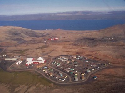
• Thanks for stopping by. Logging in to a registered account will remove all generic ads. Please reach out with any questions or concerns.

The Arctic

So what is to be done?

1) Get it ready and use it until a facility can be built and used for 3-4 months (or even longer?)
2) Scrap what has been done so far
3) Spend more money and turn it into a proper facility that can be used for 3-4 months of the year
4) Use it (whenever its ready) for the 4-5 weeks of the year that its built for

Which, in your first hand Naval experience is the best path forward for the RCN?
You follow your orders, try to make it work, and let the project become a political football is what you do. Engineering and environment don't care about your bullet points.
 
You follow your orders, try to make it work, and let the project become a political football is what you do. Engineering and environment don't care about your bullet points.
Rely on Journalists to write about the situation in order to make the general public aware of the situation and then hope that its addressed accordingly?
 
To be fair, who could have predicted that building the facility at an uninhabited, abandoned site would pose more sustainment challenges than building at an existing, populated year-round location?
 
Rely on Journalists to write about the situation in order to make the general public aware of the situation and then hope that its addressed accordingly?
At some point you need to look at it differently.

Example:
Is Alert really necessary anymore? We have satellites and OTH sensors to detect assets in the arctic and intercept Russian signals. You can automate all of Alerts functions, stream the data back to Kingston (or wherever) and do the work there. But because Alert is an expression of sovereignty and a commitment to Canada's arctic it remains as a inhabited outpost despite its complete redundancy. Nanisivik is probably going to be that.

Nanisivik could be another Alert. That was the original plan. But then it was decided to just be a gas station. So you get what you pay for, and because no one is there to ensure the infrastructure remains in repair or up to date you get these problems.
 
At some point you need to look at it differently.

E

Nanisivik could be another Alert. That was the original plan. But then it was decided to just be a gas station. So you get what you pay for, and because no one is there to ensure the infrastructure remains in repair or up to date you get these problems.
Corner Gas?

masterchef canada GIF by CTV
 
Part of the problem is quite simple, we keep trying to do defence on the cheap. Our great Northern super base is screwed because we didn't want to spend all that money for the original build and dealing with remediation and so forth.
That and kicking the can down the road almost constantly for the last twenty years or so.
What gets me is the only people who seem to be surprised that they're dealing with almost obscene cost overruns is the Government.
And they keep doing it too , over and over.
Sometimes you just have to bite the damned bullet and spend the money
Well that's my rant for the day.😉
 
At some point you need to look at it differently.

Example:
Is Alert really necessary anymore? We have satellites and OTH sensors to detect assets in the arctic and intercept Russian signals. You can automate all of Alerts functions, stream the data back to Kingston (or wherever) and do the work there. But because Alert is an expression of sovereignty and a commitment to Canada's arctic it remains as a inhabited outpost despite its complete redundancy. Nanisivik is probably going to be that.

Nanisivik could be another Alert. That was the original plan. But then it was decided to just be a gas station. So you get what you pay for, and because no one is there to ensure the infrastructure remains in repair or up to date you get these problems.

The other thing to remember is that Nanisivik wasn't virgin ground.


Nanisivik (Inuktitut: ᓇᓂᓯᕕᒃ, lit. 'the place where people find things'; /nəˈniːsɪvɪk/) is a now-abandoned company town which was built in 1975 to support the lead-zinc mining and mineral processing operations for the Nanisivik Mine, in production between 1976 and 2002. The townsite is located just inland from Strathcona Sound, about 20 km (12 mi) east of the community of Arctic Bay in the Canadian territory of Nunavut.

There is a port and dock about 3.7 km (2.3 mi) north of the abandoned mine site, which was used for shipping concentrate from the site, and receiving supplies (73°04′08″N 084°32′57″W). It is used by the Canadian Coast Guard for training.

Nanisivik Airport, located 8 nautical miles (15 km; 9.2 mi) south, was used as the main airport for Arctic Bay until 2010, when the lengthened Arctic Bay Airport took over. The airport is about 19 km (12 mi) directly southeast of Arctic Bay but the road between them is 32 km (20 mi).
The community of Nanisivik was originally built to support the Nanisivik Mine, a lead-zinc mine on Baffin Island. The mine was serviced by a jetty for receiving ocean freight, later used by the Canadian Coast Guard for training, and the Nanisivik Airport, which was capable of receiving jet aircraft and closed in 2011. Falling metal prices and shrinking resources led to the mine's closure in 2002.

On 8 August 2007, CBC News reported documents from the Canadian Forces showing plans to convert the site into a naval station. The plan was to turn the former mine's existing port into a deepwater facility at a cost of $60 million. On 10 August 2007, Prime Minister Stephen Harper announced construction of a new docking and refuelling facility at Nanisivik for the Canadian Forces, in an effort to maintain a Canadian presence in Arctic waters during the navigable season (June–October). The choice for Nanisivik as a site was partially based on its location within the eastern entrance to the Northwest Passage, via Admiralty Inlet, and the existence of a deep-water berthing facility at the site, as well as a location of the airport. The United States Air Force's Thule Air Base is 600 km (370 mi) to the northeast in Greenland.

On 20 August 2010, the Kingston-class coastal defence vessel HMCS Goose Bay became the first Canadian warship to secure to the Nanisivik jetty as part of Operation Nanook. Two days later, the frigate HMCS Montréal secured alongside for a photo opportunity. The Coast Guard icebreaker CCGS Henry Larsen was also present, but did not go alongside at that time.

Somehow we have got from a deepwater port with a jetty that could trans-ship bulk exports and incoming freight, that was on the Coast Guard's and Navy's map, that had a useable airfield airfield that could receive jets, and that previously supported a small community for 26 years to this:

In a 2024 update, it was announced the facility is slated to open in 2025. The updated site plan includes unheated fuel storage tanks and pipelines, a site office, a wharf's operator shelter, an unheated storage building, and a helicopter pad. The unheated fuel tanks require testing of the stored fuel before it can used by the docked ships. Due to the unheated fuel tanks limited capability, the base can only operate for four to five weeks before the temperatures begin to affect the stored fuel. The existing jetty underwent repair. During the COVID-19 pandemic, construction was delayed and the road connecting the base to the nearest airport washed away. The road had to be rebuilt and was again operational in 2022. Furthermore, the federal government entered into an agreement with the Nunavut government preventing any icebreaking in the area to maintain the local population's access to sea ice and protect local wildlife.

....

I can only conclude that we were different people then.

Ore discovery​

Arthur English was a prospector on CGS Arctic, the steamship of Captain Joseph-Elzéar Bernier, as part of the Geological Survey of Canada in 1910. They wintered the 1910-11 winter in Arctic Bay (20 km (12 mi) south-east of Nanisivik). In 1911 Arthur English published his discovery of a "very large body of ore" at Nanisivik.

Development​

J.F. Tibbitt and F. McInnes travelled from Churchill, Manitoba to Nanisivik by dog sled (3,000 km [1,900 mi]) and staked their claims in 1937, but were unable to develop them. In 1956 R. G. Blackadar and R. R. H. Lemon published maps of the region for another Geological Survey of Canada. Soon thereafter Texas Gulf Sulfur Company (later Texasgulf Inc., now broken up into bits such as Intrepid Potash) evaluated the region and staked 15 claims. Extensive drilling and exploration over the next decade led to the procurement of heavy equipment in 1970 and bulk metallurgical testing. Mineral Resources International of Calgary, Alberta, traded the rights to a sulphur deposit in Mexico for a long term option on the Strathcona Sound property, which eventually translated into 54% ownership of Nanisivik Mines Limited. Strathcona Mineral Services Limited was hired to run the mine as an independent manager and successfully initiated production.

Operation​

The mine opened in 1976 and yielded primarily zinc, however silver and lead were collected as by-products. It is in 500 m-thick (1,600 ft) permafrost, 700 km (430 mi) north of the Arctic Circle and operated year-round through accumulating ore during the winter and shipping in the summer (July–November). Annual production totalled 125,000 tons of ore, which was sold to European smelters via Belgium.

Conwest Exploration Company Ltd. eventually acquired the mine.

Mine closure​

Since the closure of the mine in 2002, reclamation has been ongoing and the town is abandoned. Residents of Arctic Bay had hoped that the Government of Nunavut would be able to find a new use for the former town site, potentially a trades training centre. They had also hoped to be able to move some of the buildings and equipment to their community. Due to heavy lead-zinc contamination, this was not possible and the homes have been demolished. Local telephone service was discontinued on February 19, 2007, on approval from CRTC.

As of the 2006 census the population was 0, a drop from the 2001 census with a population of 77.


....

So a northern community of 77 mostly Inuit, maintained a mine, operating heavy equipment, shipping ore in bulk from a port with jetty and airfield, for 26 years. 5 years after closure of the mine the community was still looking for opportunities to continue in existence. The government of the day did two things:

1 it cancelled local phone service
2 it announced the conversion of the facility to a naval facility.

18 years of fiddle-farting around and everything is broken and the community is dispersed - except for those people objecting to ice-breaking because they use the ice to cross the sound for hunting.

...

Start pointing fingers.
 
A 1995 review of mining operations.

The Nanisivik project is in the eastern Canadian Arctic at latitude 73° N, about 750 km north of the Arctic Circle. Winters are long and cold but temperature extremes are moderated by proximity to the Arctic and Atlantic oceans. Permafrost extends to depths of 500 m or more, and rock temperatures in the mine average minus 12° Celsius (McNeil et al, 1993). The area is a dry semi-desert with annual precipitation of 125 mm. Vegetation is sparse. Good surface rock exposure is limited to cliffs and creek beds since the more gentle slopes are covered by felsenmeer and glacial deposits.

Nanisivik has proven to be a low-cost producer despite its location. It is accessible to ocean shipping which reduces transport costs, and the deposit geology is amenable to efficient mining and milling methods. Annual output is about 100,000 tonnes of concentrate containing 55 % zinc, produced from 750,000 tonnes of mined ore. Most of the ore is mined from room and pillar stopes using wheeled equipment.

The project supports a community of 350 people, which includes a school, recreational facilities, and a jet airport. The mine staff comes from all over Canada and includes about 25 % Northerners. Most people go “out” on vacation two or three times a year.


So not 77 inhabitants but 350. The 77 sounds like the "25% Northerners" mentioned above.

Year round occupation. Seasonal shipping. Northerners and Southerners gainfully employed and raising families with enough spare change to afford to fly out for two or three vacations a year.

And when the mine closed down at least some of the locals were sufficiently attached to the place that they tried to save their lifestyle.

...

I wonder how much POL it took annually to sustain operations.
 
And it is not a one off


The Mary River Mine is an open-pit iron ore mine in the Mary River area of Baffin Island, Canada. It is operated by the Baffinland Iron Mines Corporation (BIMC). As of 2021, the operation consists of an open-pit mine, two work camps for hundreds of workers, a tote road—from the Mary River site to Milne Inlet—and port infrastructure at Milne Inlet. According to a 4-year study published in 2008, the Mary River Mine, with its four massive iron ore deposits of 65-70% pure iron ore was "one of the most promising undeveloped iron deposits on the planet". It was not until technological advances were in place in 2010, and the market for iron ore had dramatically increased that sizable financial backing was available for the high cost of development in a remote region known for its inhospitable climate. The mine began operations in 2014, and the first shipment to Europe arrived in 2015. Baffinland is currently planning on expanding the mine.

Mary River 71°19′24″N 079°12′38″W
Nanisivik 73°02′40″N 084°32′14″W

Nanisivik.jpg

Fed Nav Ships servicing the area
Arvik I - 2021 (Japan Marine United Corp, 31,000 DWT, PC4)
Nunavik - 2014 (Japan Marine United Corp, 28,000 DWT, PC4 / DNV ICE-15)
Umiak 1 - 2006 (Universal Shipbuilding Corp - Japan, 32,000 DWT, DNV ICE-15)

1747349175987.png

 
Back
Top