• Thanks for stopping by. Logging in to a registered account will remove all generic ads. Please reach out with any questions or concerns.

Canada moves to 2% GDP end of FY25/26 - PMMC

Having been in meetings with Canadian Ice Services last week, I can assure you that the North West Passage is far less passable than people think, and warming has actually made it harder to navigate, due to changes in ice patterns.

Dreams of the NWP making the Panama Canal obsolete are pipe dreams, not reality.

Suppose we don't go through the Northwest Passage. Suppose we bypass it to the south.

1750564455862.png

If I am reading this info right the ice in Hudson Bay is >30 cm or more than a foot thick but it forms fresh every year when the bay clears. It is first year ice.

There is open water at Port Nelson but to get from Port Nelson to Churchill you have to pass through water that is about half open water and half ice (yellow 4-6 tenths). To get out of Churchill there is a mix of open water (blue), 25% ice cover (green), 50% ice cover (yellow) and 75% ice cover (75%). And that ice cover is >30 cm.

Then there is a blue water passage to the entrance to Hudson Strait. The Strait varies between 10 to 50% ice cover and bergy bits. Bergy bits seems to describe the water all the way down the west coast of Greenland from Baffin Bay, through the Labrador Sea to south of the Grand Banks.

1750564455173.png

1750564455186.png
There does seem to be a bit of traffic in that bergy water, especially east of Newfoundland.

1750564598217.png Harry de Wolf is supposed to be Polar Class 5 (70 to 120 cm)
1750565446455.png FedNav's Umiak I is rated for independent ops in 1.5 meter ice (DNV ICE-15)
1750565445889.pngNunavik and Arvik are both rated at Polar Class 4 (> 120 cm ice)

1750565445900.png

Shouldn't those PC 4 and 5 ships be able to navigate even that 30 cm first year ice in the red zones?
 

Attachments

  • 1750564068028.png
    1750564068028.png
    275.5 KB · Views: 0
  • 1750565188432.png
    1750565188432.png
    356.9 KB · Views: 0
Suppose we don't go through the Northwest Passage. Suppose we bypass it to the south.

View attachment 94125

If I am reading this info right the ice in Hudson Bay is >30 cm or more than a foot thick but it forms fresh every year when the bay clears. It is first year ice.

There is open water at Port Nelson but to get from Port Nelson to Churchill you have to pass through water that is about half open water and half ice (yellow 4-6 tenths). To get out of Churchill there is a mix of open water (blue), 25% ice cover (green), 50% ice cover (yellow) and 75% ice cover (75%). And that ice cover is >30 cm.

Then there is a blue water passage to the entrance to Hudson Strait. The Strait varies between 10 to 50% ice cover and bergy bits. Bergy bits seems to describe the water all the way down the west coast of Greenland from Baffin Bay, through the Labrador Sea to south of the Grand Banks.

View attachment 94124

View attachment 94123
There does seem to be a bit of traffic in that bergy water, especially east of Newfoundland.

View attachment 94126 Harry de Wolf is supposed to be Polar Class 5 (70 to 120 cm)
View attachment 94130 FedNav's Umiak I is rated for independent ops in 1.5 meter ice (DNV ICE-15)
View attachment 94129Nunavik and Arvik are both rated at Polar Class 4 (> 120 cm ice)

View attachment 94128

Shouldn't those PC 4 and 5 ships be able to navigate even that 30 cm first year ice in the red zones?
To be clear, while mentioning the NWP, my point was, the Arctic is more complex than ever.

Ice Service Specialists, who work for Canadian Ice Services abord RCN and CCG ships, have made specific ice observations that indicate that passages in the arctic are more prone to ice related disruptions than before..

You can post all the ice charts you want, but the people who make those charts, and the people who observe the ice conditions that get added to the charts all say that the environment is more complex than before.

Just so we understand who is typing/speaking... I am the Staff Officer Meteorology for the RCN, and have regular contact with ECCC, and therefore CIS as a regular part of my job. When I make comments about Met or Ice related things on this forum, I am not just pulling ideas from the internet/my ass...
 
1750565865634.png

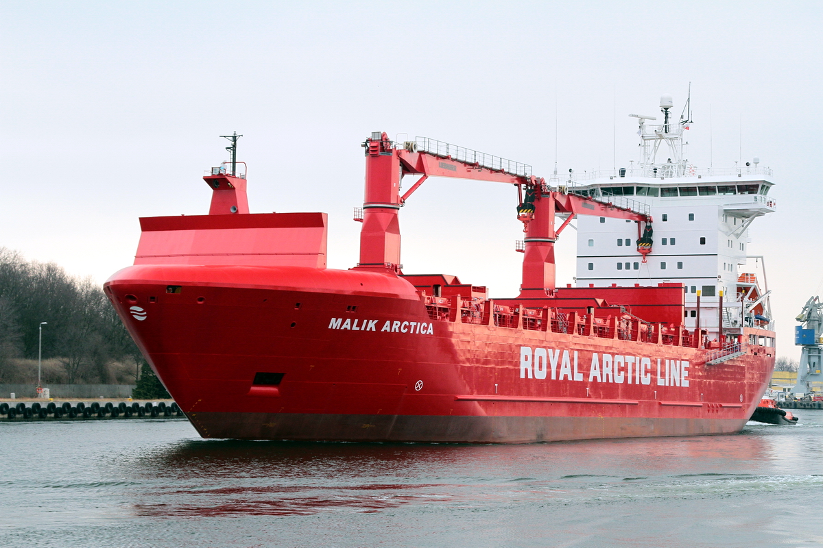
This is the Malik Arctica reported operating in the bergy water of southern Baffin Bay today.

Malik Arctica was delivered in 2017 and has a capacity of 606 TEU containers.

With its own PRAM, the ship is able to operate in places without port facilities.

The ship calls in at most towns in Greenland, both on the east coast and the west coast.

Furthermore, Malik Arctica sails in the Qaanaaq district and in Northeast Greenland in the summer months. In Northeast Greenland, the ship delivers e.g. fuel and other supplies to the Sirius Patrol (Military).


On 16 March 2017, the Malik Arctica arctic ice-classed supply vessel built at Remontowa Shipbuilding SA for Greenland’s Royal Arctic Line (RAL) left the Polish Gdansk – based yard heading Denmark. The vessel had been officially delivered to the Owners on 16 February, but remained in the yard for a month prior to its departure.

Malik Arctica is one in a series of ice-going supply vessels destined for RAL. The 606 TEU and DNV GL classed ship is a slightly modified sister to Mary Arctica, previously delivered by Remontowa Shipbuilding in 2005. The new vessel is expected to replace the 1984-built Arina Arctica.

The ship will be deployed in Atlantic route, as a feeder ship for Greenland (connecting mainly Aalborg and the Greenland capital of Nuuk, the company’s hub port). As an important and long-mooted part of the development of the country’s transport infrastructure, a new container terminal is under construction at Nuuk that is expected to open by 2017.

Malik Arctica


Class notation. 1A1 General Cargo Carrier, Container, DG-P, PC6,

DNV GL 1A1 or PC6 or 70 to 120 cm ice.
 
To be clear, while mentioning the NWP, my point was, the Arctic is more complex than ever.

Ice Service Specialists, who work for Canadian Ice Services abord RCN and CCG ships, have made specific ice observations that indicate that passages in the arctic are more prone to ice related disruptions than before..

You can post all the ice charts you want, but the people who make those charts, and the people who observe the ice conditions that get added to the charts all say that the environment is more complex than before.

Just so we understand who is typing/speaking... I am the Staff Officer Meteorology for the RCN, and have regular contact with ECCC, and therefore CIS as a regular part of my job. When I make comments about Met or Ice related things on this forum, I am not just pulling ideas from the internet/my ass...

I understand your qualifications and respect them. That is why I am asking questions.

Cheers.
 
I understand your qualifications and respect them. That is why I am asking questions.

Cheers.
My point wasn't to stifle discussion, just to add some weight to the reality on the ground.

The environment has become more difficult, and less predictable. Which means we need to be more cautious about shipping in the arctic.
 
I guess I am just trying to understand why all the interest, why people like FedNav are investing in ice-capable ships to service arctic mines, why there is active promotion of the Hudson Bay route.
 
  • Insightful
Reactions: ueo
Back
Top