- Reaction score
- 13,685
- Points
- 1,160
Having been in meetings with Canadian Ice Services last week, I can assure you that the North West Passage is far less passable than people think, and warming has actually made it harder to navigate, due to changes in ice patterns.
Dreams of the NWP making the Panama Canal obsolete are pipe dreams, not reality.
Suppose we don't go through the Northwest Passage. Suppose we bypass it to the south.

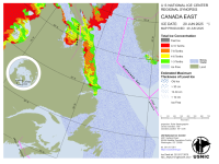
If I am reading this info right the ice in Hudson Bay is >30 cm or more than a foot thick but it forms fresh every year when the bay clears. It is first year ice.
There is open water at Port Nelson but to get from Port Nelson to Churchill you have to pass through water that is about half open water and half ice (yellow 4-6 tenths). To get out of Churchill there is a mix of open water (blue), 25% ice cover (green), 50% ice cover (yellow) and 75% ice cover (75%). And that ice cover is >30 cm.
Then there is a blue water passage to the entrance to Hudson Strait. The Strait varies between 10 to 50% ice cover and bergy bits. Bergy bits seems to describe the water all the way down the west coast of Greenland from Baffin Bay, through the Labrador Sea to south of the Grand Banks.


There does seem to be a bit of traffic in that bergy water, especially east of Newfoundland.
 Harry de Wolf is supposed to be Polar Class 5 (70 to 120 cm)
 FedNav's Umiak I is rated for independent ops in 1.5 meter ice (DNV ICE-15)
 Nunavik and Arvik are both rated at Polar Class 4 (> 120 cm ice)
Shouldn't those PC 4 and 5 ships be able to navigate even that 30 cm first year ice in the red zones?