daftandbarmy
Army.ca Fossil
- Reaction score
- 46,925
- Points
- 1,160
We'd better break out the Wildfire 2026 thread... this weekend should be a doozy ")

Was on 4 in the last week. Cured grass and stupidity is not a good combination.We'd better break out the Wildfire 2026 thread... this weekend should be a doozy
We'd better break out the Wildfire 2026 thread... this weekend should be a doozy


Its going to be a hot summer in the west, thats for sure. Hope the IRUs and ARes are readyCongrats, or not, on breaking all those old records BC....
As near as I can tell, wherever it's the hottest is nowhere near where you are.Congrats, or not, on breaking all those old records BC....
Congrats, or not, on breaking all those old records BC....
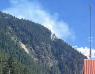
Had to drive to Abbotsford Monday for a hydraulic part, passed this wildfire at the top of the mountain precisely at Hells Gate canyon. Temp was 32C. That whole Fraser River Valley from Hope to Lytton is a gigantic tinder box, and it has been struck repeatedly with enormous wild fires year after year.
The entire Okanagan is in extreme drought and extreme fire danger, and that’s an understatement.

Probably not that entire distance. Cloud formations come in from the west (Pacific), and if they aren't high enough to pass over the mountains, they bottleneck and concentrate at the head of the Fraser Valley, which is Hope. (Travel through during a rainstorm sometime so you can experience the torrential downpours along the part of the highway that is right beside the mountains west of Hope.) From there and a ways further into the passes (Hwy 1, 3, and 5), things generally are not as dry as eastwards. Lytton, however, is a hot spot - has ever been thus. If I had to roughly pick a transition point from reasonably wet to unreasonably dry, I'd nominate Boston Bar. From there eastwards the low country (valleys) are and look parched, but the high plateau is not as extreme.Had to drive to Abbotsford Monday for a hydraulic part, passed this wildfire at the top of the mountain precisely at Hells Gate canyon. Temp was 32C. That whole Fraser River Valley from Hope to Lytton is a gigantic tinder box, and it has been struck repeatedly with enormous wild fires year after year.
Huh. Eby's government should legislate wildfire bans.Campfire bans are starting early this year...
Huh. Eby's government should legislate wildfire bans.
Well we are now at Stage 5 Drought for the entire Okanagan. It’s because of low snow pack and early melt.
I’ve been asked to shut off the irrigation pivot and the guns. Done.
Trying to make arrangements to have water tanked in to the storage tanks. So far way too expensive.
However, as kind of a blessing we’ve had rain about every other day so things are not overly dry.
That being said we all expect the region to burn and burn and burn this summer.
That’s because the rednecks from you-know-where haven’t yet arrived with their big RVs, boats, ATVs, sea doos, and their “in our province we can do this, so you’re province is retarded” attitude.
We call them Easterners.Aw... such a great description of Albertans
Wait, I'm from farther east, so shouldn't you call them "Middle Easterners"?We call them Easterners.
Which really pisses them off, apparently.
Wait, I'm from farther east, so shouldn't you call them "Middle Easterners"?